Nau mai ki (welcome to) Location 3: Williams Street
This commentary explores…
- In the area: points of interest
- Evidence of Māori settlement
- the Mahurangi Heads School
- Motukauri (Grants Island) and the graves it may hold
- the Kaiho and Waihē (Mahurangi Harbour and River)
- the rise and unspeakable fall of Philip Dyer of Dyers creek
- Gordon Browne and how his spar trade was usurped by HMS Buffalo in 1834
Read on to explore the history of this area you see from this vantage point. Scroll or use the buttons to skip to the stories you want to read.
Kia mahara mai (please note): MERRA’s Historical Trail commentaries are draft working documents compiled by volunteers. They will be revised through on-going consultation and research and as feedback is received.
We invite constructive feedback, wider perspectives, additional information, and suggestions for improvement. Please be in touch via the contact form on this website.
Points of interest you see from this vantage point
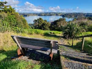
In the area: This is one of the highest points of the peninsular overlooking the headland of the Burton Wells Reserve (Department of Conservation) flanked by Anderson’s Bay (right) and Schoolhouse Bay (left). This area would have once echoed with the voices and waiata (singing) of Maori and later the voices and waiata of local school children.
On the central bush-covered headland is one of the notable pā sites that reference this area’s rich Māori history.
The former Mahurangi Heads School occupied a grassy area on the saddle in the foreground from 1861 until its removal in the 1990s.
This bench sits at the junction of Williams and ‘Bay’ Streets. These unformed (and impracticably steep) roads hail from Denham’s 1852 subdivision map previously discussed at Location 2. Both ‘roads’ now host public walkways that lead to the shorelines of Schoolhouse Bay (left; down ‘Bay’ Street) and Anderson’s Bay (right; down Williams Street). There is a connecting track (on another never-to-be-formed road) that traverses the saddle at the bottom of this spur beyond the former school site.
Evidence of Māori settlement:
Substantial defensive earthworks and fortifications of a ‘ring pā’ remain evident on the headland below.
Significant shell middens from kaimoana are visible in eroded areas along the shoreline. They are physical reminders of the seasonal visits and longer term occupation by Māori in this area over many centuries. Māori knew this harbour as Kiaho and the river upstream as Waihē.
Plentiful fishing grounds underpinned settlement here. Despite most local soils being poor and fresh water scarce the presence of kumara pits on the peninsular and on the motu [islands] beyond including Motu Maunganui [Casnell Island] just off Scott Point suggest that Maori successfully cultivated locally-grown crops. Kumara would have been a welcome supplement to the ubiquitous local fern root (aruhe). Both were a staple source of carbohydrate.
Other crops would have included hue (gourds), uhi (yams), building and weaving materials like raupō, kuta and harakeke (flax). Coastal forests would have supplied medicine and building and fishing materials. Plants like whau, ngaio, nīkau palm, toetoe, karaka, tawāpou, pōhutukawa; and birds like tūī, kūkupa (native pigeon) and kākā.
Māori harvested the area’s marine resources all year round, including fish, kōura (crayfish), pipi, tuatua, tuangi (cockle) and tipa (scallop), kina, pāua, kūtai (mussel), tio (rock oyster), pūpū (catseye) and kākara (whelk).
Occasional stranded whales (such as the pictured stranding of a Bryde’s whale to your right in Andersons Bay in 2013) provided food and bone.
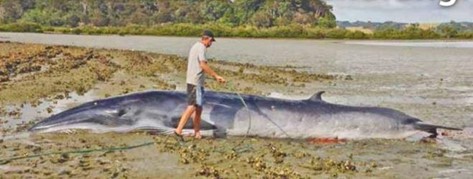
Image courtesy of Mahurangi Matters, 1 March 2013
Looking at the view here one can imagine the waka pulled up in the adjacent bays, racks laden with drying muru (small spotted shark) and other kaimoana (sea food), clearings with growing ngā kai (crops), whare (houses/shelters), smoke from cooking fires drifting in the air, and the imposing defensive ditches and palisades of the pa itself.
The next commentary at Location 4 (below here tucked in at the northern end of Schoolhouse Bay) includes a more in-depth discussion of pā in the area. Commentary at Locations 6 discuss the area’s Māori history in greater depth.
The Mahurangi Heads School

The old Mahurangi Heads schoolhouse in 1987 not long before its demolition with Burton Wells Reserve and pa site beyond (Sir George Govenor Grey collection, Auckland Libraries)
The school established here in 1861 pre-dated the Education Acts of 1867, 1872 and 1877 that empowered school committees to establish and manage local schools.
- M. Locker in his book Jade River records that the school was established under Presbyterian oversight.
In 1878, when the Auckland Provincial Gazette published a list of local schools and roll numbers, it reported Mahurangi Heads School’s roll as 34 pupils. A contrast to the handful of students who catch the local school bus today.
By comparison Little Omaha School (Leigh) had 33, Mullet Point (Mātairoa near Scandretts Regional Park) 28, Big Omaha (Whangateau) 19, Lower Matakana (Sandspit) 19, Kaipara Flats 14 and Matakana 13. (https://www.localmatters.co.nz/opinion/mahurangis-first-schools/)

The schoolhouse c1970 with chimney and corrugated 500 gallon watertank still in place.
Peter Greenhill was the founding teacher at Mahurangi Heads School, serving for 23 years until hearing loss forced his retirement. His replacement taught 3 days at Mahurangi West and 3 days here each week. The change of location involved rowing across the harbour.
The NZ Herald (see below) reported a meeting of the Mahurangi Athenaeum (Library) subscribers in the schoolhouse on 29 January 1886 and noted an expanded holding of over 400 books available for loan. Like the local church (see Location 1) the schoolhouse also served a wider community purpose. Visitors to the schoolhouse in its final years report these library books still in the cupboards. The local library tradition continues with the current community ‘Little Library’ located on the corner of Charles Street and Ridge Rd.

Two outhouses (girls and boys) catered for toileting needs of pupils and visitors alike. Long after lessons ceased they remained a local talking point with one re-purposed as a generously sized smokehouse. Contemporary accounts are that it produced beautifully finished and no doubt flavoursome smoked fish.

One of the school outhouses; whether this one was the boys’ or girls’ or eventually the fish smokehouse is unclear.
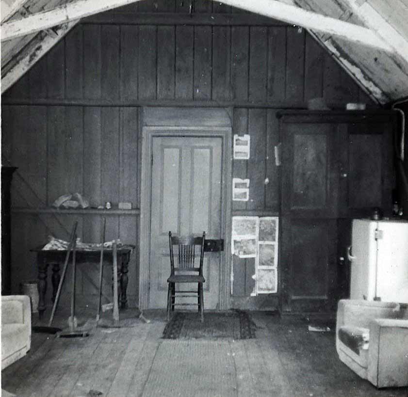
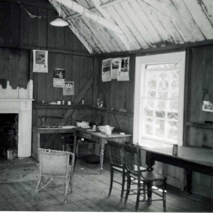
Visitors report that long after its closure the schoolhouse interior remained ‘as if ready for lessons’. These pictures taken in the 1950s or 60s illustrate the time capsule contained within.
The remnants of an orchard including sprawling quince trees on the flats to the right (north) of the headland suggest that there may have been a dwelling (possibly the teacher’s cottage) there at some stage.
Motu Kauri (Grants Island)
Motu Kauri up river to your right appeared in the 1834 HMS Buffalo survey by the transliteration Motu Cowdie. It has also been known as Pine Island and Pudding Island. Lately more commonly known as Grants Island (after European settler and church benefactor William Grant referenced at Location 1). The island has an interesting history of Maori occupation (perhaps as a pā or maybe as a fortified lookout).
Auckland council assessments include the following:
‘A number of terraces and at least one pit are visible on the island … midden containing predominantly whole and crushed cockle shell with pipi, scallop, whelk. Mussel, fire-cracked rock, burnt shell and charcoal is visible eroding out of a number of areas on the island, particularly from the large (21m x 4m) terrace on the western side and in an erosion scarp on the north-eastern side of the island.’
‘Almost the entire surface of the island, and particularly the lower slope to the north-east, is covered with a layer of midden up to 0.40 cm thick, comprising mostly cockle, but with some pipi, topshell, oyster and amphibola. A small shark vertebra, and a bone from the tail of a snapper, of about 0.35 m were also seen.
‘The island is extensively terraced and it is quite possible that it was a defended island pā.’ (see https://scottslanding.org/grants-island/ for acknowledgements and further information)
Motu Kauri may also hold the graves of executed convicts and possibly the captain of the 380 ton timber ship ‘Nancy’ who was killed in a loading accident in 1832. There are first hand reports of marked graves on the island in 1888.
Legend has it that two convict labourers on board HMS Buffalo in 1834 were executed and buried there after killing their guard.
This early photograph of Grants Island taken from close by shows a fuller profile and far fewer mangroves on the reef to the left and the Andersons Bay in the foreground.

The Kaiho and Waihē (Mahurangi Harbour and River)
Beyond Motu Kauri the river leading up the valley to present day Warkworth was once a busy seaway with traffic only abating from the 1930s as all-weather roads were built.
Prior to European settlement fishing (particularly for shark) saw a large seasonal population of Māori in the area. There are reports of fertile gardens up the river valley especially beyond the tidal reach where soils were more fertile and fresh water more readily available. Vibrant inter-hapu and inter-iwi trade meant cargoes of kaimoana (seafood), berries, birds, obsidian, argillite, basalt and maybe sometimes even south island pounamu (greenstone) would have passed by here.
From Victorian times the river was also busy with local European settlers in their flat bottomed rowing punts, sail trading vessels of various sizes, and later the regular coastal steamers calling at Scotts Landing and Warkworth as part of their scheduled passenger, cream/milk and freight runs.
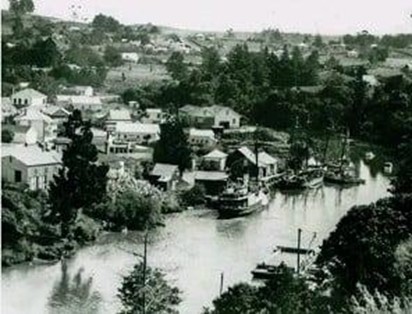
A busy port. A coastal steamer (possibly the ‘Kapuni’ that later caught fire in the same location) and two scows tied up at the Warkworth wharf about 1914 (see https://www.pressreader.com/new-zealand/boating-nz/20210501/281599538350306)
The Rise & Unspeakable Fall of Philip Dyer
Dyers Creek flows down past an early pā and cultivation site into the Mahurangi opposite here. (Look slightly right across the river to the left of the large area of regenerating native bush of the McElroy reserve) The creek is tidal up to a small waterfall a kilometre or more upstream.
After purchasing a Government cutting right for £5, Philip Charles Dyer (occupation sawyer/firewood cutter) set up camp in 1846 with his wife Eliza (nee Smith). A son, George, was born in 1847. Dyer and his neighbour Henry Cowan (also a sawyer) built the schooner ‘Post Boy’ in 1849. The build site was probably on the creek bank near the bush line where shards of iron and pottery have been discovered. Dyer and Eliza soon moved on to Pakiri where their business in timber and shingles flourished. The Mahurangi-built ‘Post Boy’ was used to deliver wood products to the Auckland market.

The family grew to 7 children. The Dyers established a busy store, post office and built a school for local Maori and settler children. A tragic turning point came after Eliza died aged 52 in June 1870. Dyer’s took to drink and an abusive relationship with his niece Elizabeth Battersea.
Dyer was hanged in 1874; guilty of murder. The court established that his brutal abuse of Elizabeth (she too was known as Eliza) had culminated in him dousing her with kerosene and fatally setting her alight.
For more history and references/acknowledgements see http://early-history- auckland.blogspot.com/2014/03/murder-at-pariki-northland- and.html and http://www.mahurangi.org.nz/2018/04/11/boatbuilding-begins-in-the-mahurangi/
Cowan’s Bay is the next bay north and where Henry later set up a brick-making operation. The large (144 ha) area of native bush opposite between Cowans Bay and Dyers creek is McElroy Scenic Reserve. It was vested in Council by the McElroy brothers. Their large farm, Wicklow Hills, was purchased from an uncle, John Campbell, in 1901. Its interesting history will be discussed at Location 5 (Ngaio Bay).
Gordon Browne
Brownes Bay: On the opposite bank to the left of Burton Wells Reserve is a narrow pine-tree clad point and a wide shallow bay to its right. This bay, later to be part of McElroys’ ‘Wicklow Hills’ farm, was the site of Gordon Davies Browne’s kauri spar station. It was the first European settlement on the Mahurangi. Timber breastwork, Sydney-made bricks and pottery shards still mark the site. Fluent in Te Reo Maori, Browne was a swashbuckling figure in early New Zealand and New South Wales. After close shaves and mixed fortunes in the early flax and timber industries, Browne arrived from Sydney (with entrepreneur Captain Dacre) aboard the 243 ton brig ‘Bolina’ in May 1832. They were armed with a dubious 5000 acre ‘purchase’ from Puhata, William Pepena and others (chiefs of Ngāti Pāoa) and a contract to source 115 masts and 500 loads of timber for the sum of £750. They brought a team of fifteen carpenters and sawyers with them.
When missionary Henry Williams visited in April 1833 the operation was well underway. Browne was resident with ‘Jess’, his high ranking Ngāti Pāoa wife and storekeeper. Jess was to give birth to a son during their time at Mahurangi. Dacre too was still present. A team of 30 workers including many Maori were busy felling, squaring spars and cutting timber. Once prepared, stockpiled timber was loaded onto ships, via a tunnel (now collapsed) cut through the point. The remaining ‘notch’ is still visible. The sailing ships anchored in the deeper water of the next bay.
Browne was enraged when the Admiralty stores ship HMSS Buffalo arrived in 1834 to commandeer spars. Captain Sadler’s willingness to offer muskets, bayonets and shot as payment seriously impacted Browne’s on-going ability to retain and re-recruit Maori workers. There was also friction with local (Te Kawerau) Maori who disputed the land-sale and resented the presence of Browne’s Ngāti Pāoa workforce. These ongoing tensions and problems with quality control meant that the spar station was shortlived. Dacre instructed Browne to relocate the operation to Whitianga in 1835/6. Browne’s mixed fortunes continued. He died aged in the Bay of Islands in 1841, a broken man not yet 40.
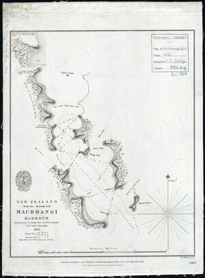
In 1834 HMS Buffalo’s first mate F A Cudlip carried out the first detailed part-survey of the Mahurangi. His map is reproduced below with Motu Cowdie (Grant’s Island) opposite Dyers Creek near the top and Browne’s spar station marked middle left inside a narrow peninsular.
For acknowledgements and further detail see http://www.mahurangi.org.nz/2017/05/21/gordon-
browne-spar-station/, https://teara.govt.nz/en/1966/browne-gordon-davies and
https://scottslanding.org/early-europeans/
Next Location: to reach Historical Trail Location 4 (Schoolhouse Bay), head down the steep concrete drive that is Williams Street (to your right). At the very bottom of Williams St (beyond the concrete, as you near the shoreline) you will see a public walkway marker. Turn left into the bush, cross the small bridge and take the track up and over the saddle. Close beyond the bridge a vague track to your right leads to the orchard remnants referred to above. Further on at the highest point there is a glimpse beyond the oak tree on your left of the grassy paddock where the schoolhouse once stood to your left [Please note that beyond the fence line and gate is PRIVATE PROPERTY, please respect this]. The pā site in the adjoining Burton Wells Reserve is to your right. Proceed straight ahead down to the shoreline clearing where you will find Location 4.
Browned bay, 3 pah sites in view, heaphy house left below, school house right below mcilroys across on left
Hi Mark… Thanks, good to know you are keeping an eye … still very much work in progress getting these draft commentaries loaded. Brownes Bay is in the commentary for Location 5 (previously Location 1), Heaphy and McBrierty’s cottages discussed at Location 4, and more on pā sites at 4, 5, and 6.
Awesome history! Well done. I might kayak over to Grants Is. To check out the middens.