The article on this page was researched, developed and created by John C Waugh, for use on the MERRA website. It presents the author’s findings based on that research. Some of his conclusions are different from that presented in some historical texts, but unless otherwise stated, are supported by contemporary evidence sighted. Many of the photographs and documents presented in or accessible via this website version of the article were made available for this purpose by current or past residents of our community, and the public at large. Other images and media excerpts are taken from public data bases. In the final analysis, the article provides the author’s take on our past history.
Grants island (Motu Kauri or Motukauri)
Where Is Grants Island..?
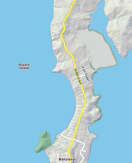
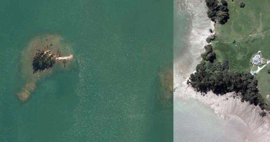
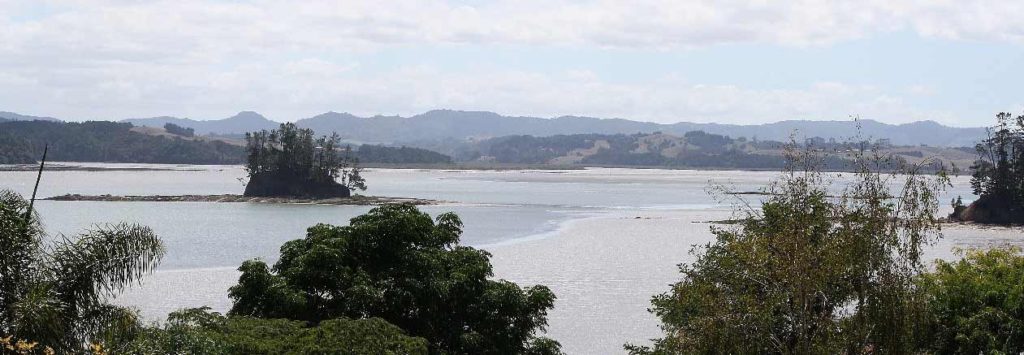
Located in the Mahurangi Harbour, just off the Scotts Landing peninsula, in the area nowadays known as Anderson Bay, is a small island that generally is referred to as ‘Grants Island’.
The two map graphics below provide an indication of the island’s relationship with the Scotts Landing peninsula:
Auckland Council, in a glossary of terms relating to the geology and landforms of islands within the greater Auckland area, identifies Grants Island as being ‘top hat island’. Council defines this as:
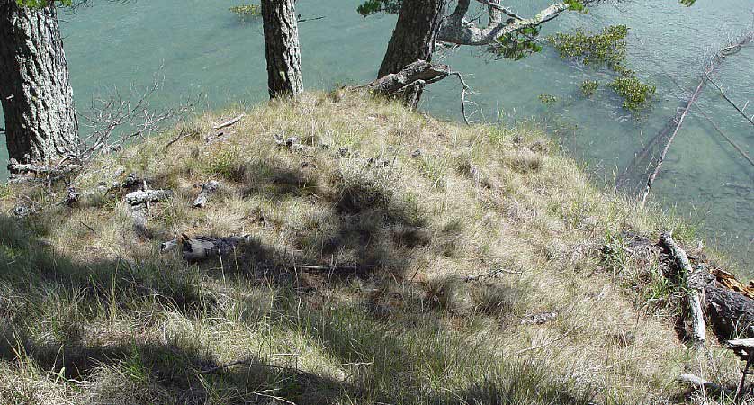
‘a small island with the shape of a top hat when the tide is out, formed by a central remnant islet surrounded by a wide shore platform’.
In Council’s documentation relating to its presently proposed Unitary Plan, it records Grants Island as being one of the best examples in New Zealand of a small island surrounded by broad intertidal rock platforms, giving it the classical ‘old hat’ shape.
Geological Considerations
Local residents sometimes think of Grants Island as being the last vestige of an area of land that long ago, in the general area where the Mahurangi Heads cemetery is located, had formed part of the peninsula. Those residents believe that the separation of the two land areas is the result of many years of erosion by weathering and sea-borne coastal erosion. In short, that the island is the remnants of a ‘stack’ (as such land structures most commonly are called).
Council geologist Alistair Jamieson has confirmed to us that the island’s separate existence from the peninsula is the result of sea level changes and land erosion over millennia. The separation was not by reason of geological forces. He suggested that in the distant past, the island perhaps was part of a ridge of land which was itself separated from the peninsula land by a river … the changing forces of nature very slowly changing the terrestrial scene to what we find now.
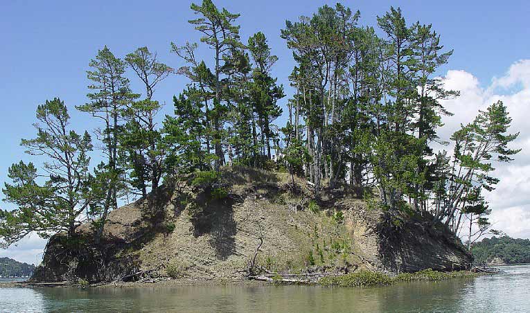
Images taken in the 1940s shows Grants Island largely unchanged over time


An Island by any other name.
Though the island nowadays is commonly referred to as Grants Island, over time, it has been accorded other names.
The Mahurangi Harbour area has a long history of Māori occupation and ownership. One aspect of Maori presence in the area is of particular relevance to the naming of the island. In years gone by, at the southern entrance to the harbour, at Te Korotangi, was a fortified pā. A certain Maki and his wife Rotu occupied that pā. They were Ngāti Manuhiri. The island stack we know as Grants Island was known by them as Motu Kauri (or Motukauri).
Historian Harry Bioletti, in his work ‘Warkworth Roundabout’, records that:
‘Grants Island was marked on the HMS Buffalo chart of 1834 as ‘Motu Cowdie’, the island of kauris’
… seemingly, a transliteration of the Māori name ‘Motu Kauri’.
In a Māori culture-related document recently submitted to the New Zealand Transport Agency [NZTA], it is recorded that Motu Kauri remains of particular significance to Ngāti Manuhiri. The reason for the island being of ‘particular significance’ is not readily apparent from that documentation, but later in this vignette we note a possible explanation.
Of course, from the 1830s onward, the Mahurangi Harbour area was visited by, and progressively settled with, people of European origin, with English the principal language. So, it isn’t surprising that at some stage, the European community would give the island a European name.
If you were to chat with local residents, you are likely to be told that Grants Island is named after an early settler named Grant (sometimes, more specifically, as ‘William Grant’).
In his work ‘Jade River – A history of the Mahurangi’, Locker records that William ‘Tar’ Grant:
‘… came to Auckland in 1842, and on to Mahurangi, where he worked as a sawyer. He is said to have built two ships on the beach near the island that bears his name. In 1853 he purchased 80 acres there (and three lots in the Mahurangi Village) …
‘Tar’ Grant is remembered as donor of the site of the Mahurangi [Heads Presbyterian] church, which he helped to build … At the ripe age of 98, he was buried in its yard.’
Historian Harry Bioletti, in his book ‘Warkworth Roundabout’, states (without any related commentary) that the island was:
‘named after the settler who had a holding nearby’.
The Heaphy / Denham survey map of Mahurangi Township drawn up in 1852/53 notes that land on the Scotts Landing peninsula in the proximity of Motu Kauri was owned by ‘J Grant, W Grant’. At first blush, either or both of them might have lent their name to the island. This is a matter we may further examine at a later date.
However, at this stage in our research, we have found nothing to contradict the assertion that William ‘Tar’ Grant was the person after whom Grants Island is named. It is he who is recorded as being the person who, c.1863, gave a tranche of land to the Presbyterian Church of New Zealand for the building of a church at Mahurangi Heads. This gift is affirmed by the following statement in the John Dixon’s 1899 book titled a ‘History of the Presbyterian Church in New Zealand’:
‘In 1864 a church was erected at Mahurangi Heads, on a site given by Mr W Grant, and opened on March 13th by Reverend Jas. Hill’
William Grant is buried in the church cemetery. A photograph of his gravestone [link required] may be viewed in our historical vignette focused on the Mahurangi Heads Presbyterian Church.
The connection between William ‘Tar’ Grant and the land on the peninsula in the proximity of the island seems to be a matter of historical record. There seems little likelihood that Grants island is named by reference to any other person than he. But that leaves open the question as to when the island first was commonly referred to as ‘Grants Island’.
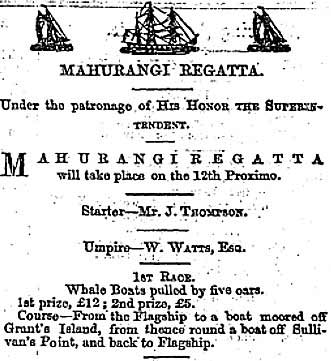
Our researches established that by the end of 1864, the local community had begun referring to the Motu Kauri as ‘Grant’s Island’. For example, the New Zealand Herald, Issue 360, 6 January 1865, at page 3 carried an advertisement for the 1865 Mahurangi Regatta. Here is an excerpt from the advertised programme:
<align=”left”>This was not just a solitary reference to the local (and indeed wider) community calling the island by that name. There are numerous examples to be found in the ‘Papers Past’ database. Here is an outline of some of those examples:</align=”left”>
The Daily Southern Cross, Issue 5615, on 25 August 1875, at page 3 reported on the disappearance of a certain Mr Pilkington. A certain Mr Parker and party took a boat and examined mud flats, and half tide rocks, Grant’s Island, and so on.
In the New Zealand Herald, Issue 10915, of 21 November 1898, on page 6, there is a report about how, early of an evening, the steamer Kapanui dropped down from Warkworth to Grant’s island in order to get away early in the morning to Auckland.
The Auckland Star, Issue 3, of 4 January 1904, at page 2 carried an article on the recently held Mahurangi Regatta, and refers to the course passing round Grants Island.
In the Auckland Star, Issue 290, of 8 December 1932, at page 7, there is a report about an individual who had his hands badly lacerated by a grey nurse shark while fishing off Grant Island near Mahurangi Heads.
And so on.
In summary, it appears that the island has throughout retained the Māori name of Motu Kauri. And at least as early as 1865, the island was known by the local settlers and traders as ‘Grant’s Island’.
So it was with some surprise that we learned that Auckland Council’s heritage records note that the 1928 Geological Survey map refers to the island as ‘Pine Island’ … a name which, given the (now residual) assortment of pine trees growing on the island, might seem to be logical English nomenclature. Perhaps the geological surveyors were unaware that the island already had both Māori and local names?
We have not checked how the island was described on maps and charts prepared in the time interval between 1834 and the release of the 1928 survey map. Nor have we researched when it was that geographic and geological survey maps first acknowledged the island as being ‘Grant’s Island’ (and, in turn, with the modern-day approach of dropping off apostrophes that appear in place names, ‘Grants Island’).
What do we actually know about the Island..?
Auckland Council record the Crown [NZ Lands and Survey] as the current owners of the landmass that comprises the island.
The current Council historical assessment of the island records that it constitutes an archaeological site.
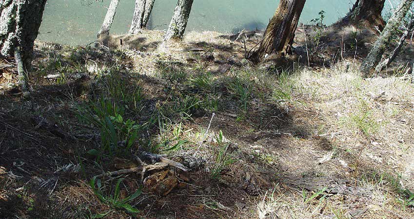
In Council’s 2005 geological assessment of the island, it was recorded that there was gradual erosion around the edge, and that unstable pines were widespread. These pines were accelerating the erosion. It also was noted that there was continuing minor damage.
Here are some excerpts from the additional comments recorded in the assessment record.
‘A number of terraces and at least one pit are visible on the island … midden containing predominantly whole and crushed cockle shell with pipi, scallop, whelk. Mussel, fire-cracked rock, burnt shell and charcoal is visible eroding out of a number of areas on the island, particularly from the large (21m x 4m) terrace on the western side and in an erosion scarp on the north-eastern side of the island.’
In May 2010 there was a further Council assessment of the island. We quote excerpts from that Council assessment.
‘Almost the entire surface of the island, and particularly the lower slope to the north-east, is covered with a layer of midden up to 0.40 cm thick, comprising mostly cockle, but with some pipi, topshell, oyster and amphibola. A small shark vertebra, and a bone from the tail of a snapper, of about 0.35 m were also seen. No attempt could be made to subdivide the midden from a surface examination, but it seems likely to be a series of small deposits.’
Council notes that:
‘The island is extensively terraced and it is quite possible that it was a defended island pā.’
That ‘possibility’ perhaps links well with the cultural assertion made, in submissions to the NZTA, about Motu Kauri being ‘particularly significant’ to the Ngāti Manuhiri. In the months ahead we hope to be able to meet with Ngati Manuhiri representatives to learn more about their cultural history of the island and its significance to them.
Are there graves on the Island... and is the land tapu
Some local residents refer to the island as being tapu … the perceived reason being the graves that historians believe exist(ed) on the island. Later in this vignette we provide specific comment on this matter. In the meantime, you should recognise that most of the land in the area now known as Scotts Landing (and on the Eastern Peninsula) was previously occupied by Māori … so it is hardly surprising that some locations may have been declared, or came to be believed, sacred.
With respect to the purported graves and tapu status of the island, the Council’s heritage records pertaining to a 2010 visit to the island state that:
‘There are plenty of locations for graves. However no obvious signs of depression were noted.’
Bioletti, in his book ‘Warkworth Roundabout’, records that:
‘A party of men and women staying with the Morrisons at Red Bluff Orchard in 1888 records climbing to the top of the island and seeing three graves there.’
But, is there any historical support for these propositions?
There is historic evidence that:
‘… on 8 February 1833 [Gordon Davi(e)s] Browne wrote to British Resident James Busby complaining that two seamen, Robert Ferguson and William Martin, had deserted the ship and stolen a boat and sails belonging to Browne (Browne 1833a).’
‘On 22 August 1833, the Sydney [Morning] Herald reported that Captain Williams, [skipper of the ship Nancy,] had [when the ship was loading spars at the Mahurangi sawmills in June that year] been killed … (SH 22 August 1833: 3/2).’
Robert Brassey, Auckland Council’s principal specialist for cultural heritage, has kindly provided us with text excerpts from an (as yet unpublished) report entitled: “A bay where no ships have been: the history and archaeology of Browne’s spar station, Mahurangi”. Set out below are key elements from that text:
‘According to Henry Pulham, the aforesaid Captain Williams was killed during ‘a spar loading accident’ in 1833, and was buried on Pudding Island. … ‘
‘The island currently known as Pudding Island is a very small island at the entrance to the Mahurangi Harbour. The original Māori name of this island is Kiaho. [It] … is more of a rock stack than an island and seems an unlikely place, because of its size, for anyone to have been buried. It would certainly be too small today, and does not appear significantly larger in a sketch by James Coutts Crawford dating from 1864 (reproduced in Locker 2007:56). … ‘
‘A reprinted version of Pulham’s paper clarifies that Pudding Island is [or was at that time] … the little pine-topped island abreast of Mahurangi Heads church … (Rodney and Otamatea Times 30 August 1922: 4/4). This island is Motukauri, subsequently known at various times as Grants or Pine Island. It is pudding-shaped … and is close to the site of Browne’s spar station and to where the death would have occurred.’
‘Locker (2007: 57) makes reference to an 1888 report of three graves on Motukauri. He speculates that these might relate to an incident recounted in a local tradition. The tradition refers to an incident in which two convicts were executed after killing their guard. Locker was of the opinion that the incident probably took place while the Buffalo was at Mahurangi. The latter would appear unlikely since it would have been a noteworthy incident but is not mentioned in any of the primary accounts of the Buffalo visit. It is quite conceivable however that further graves associated with the spar station are present on the island in addition to that of Captain Williams.’
‘Motukauri has been surveyed and there is a recorded archaeological site on the island (Auckland Council Cultural Heritage Inventory [CHI] No. 5366 – terraces/midden/pits associated with Maori occupation). There are no obvious depressions that might indicate graves. However there are terraced areas that would be quite a suitable location for a small cemetery. The graves have been recorded as a reported historic site in the CHI (No.18534).’
Below are a few footnotes to Robert Brassey’s text. They primarily are based on the texts provided to us:
‘The reprinted text of the Henry Pulham paper (which we referred to above) was entitled “The days of long ago: As told by the late Mr Pulham a quarter of a century ago”. Paper read to the Mahurangi Mutual Improvement Society in Warkworth. Ms. (said to have been published in the Warkworth newspaper, September 1909) Dept Lands and Survey file 14/61, folio 141, 25 May 1951. Pulham’s article, written in 1884 and reputedly published in 1909, is of interest because he was recording history at a time when one at least one of Browne’s former employees was still alive and living in the district.
‘The harbour was charted as Kiaho Harbour in 1820, and Europeans continued to refer to the harbour by variants of the name Kiaho in some cases as late as the 1850s. However the use of this name declined after the harbour was charted as Mahurangi Harbour by Frank Cudlip during the HMS Buffalo visit of 1834. On that chart, the island nowadays referred to as Pudding Island was labelled ‘Kiahou’ (while, as we noted in our tale, Grants Island had been labelled Motu Cowdie).
‘It is difficult to establish when the name ‘Pudding Island’ was swapped from being a reference to Motukauri, to being (on that 1928 geological map upon which Motukauri is labelled ‘Pine Island’) a reference to Kiaho. On the 1942 Warkworth topographic map, Kiaho is labelled as ‘Pudding Island’. So it appears that the confusing name change may have happened around the 1910 – 20 period.

The Vascular Flora on Grants Island
In late 2015, respected Warkworth botanist Maureen Young undertook an examination of the vascular flora present on Grants Island. She has provided MERRA with a copy of the paper she authored, setting out her findings. Her paper was published in the Auckland Botanical Society Journal, Volume 71(1) – June 2016. With the author’s kind permission, we have been able to upload a copy of that paper onto our server, and make it available to our viewers. You may wish to download it, and learn what she found: Vascular flora of Grants Island.
Other Information relating to Grants Island
On 28 February 2010, the waters of the Mahurangi Harbour experienced a ‘great tidal suck’ … relatively minor (but conspicuous) flow-on effects from a major overseas tsunami. On two occasions during the event, for a brief period, the channel of water between the island and the peninsula was substantially drained of tidal water. The image below depicts the ‘great tidal suck’ in progress:
And, we can tell you that in 2010, when Council personnel visited the island, they found two small peach trees on the island!
Matters we have yet to address
There are a number of matters which we either have not yet addressed, or in relation to which we wish to undertake further research. Some of these are briefly noted below:
Rachel Ford, of Auckland Council’s heritage team, has provided us with information that will allow us to make contact with Ngati Manuhiri representatives. We hope that this will give us the opportunity to learn more about the historic and cultural significance of the island to Māori.
We should like to formally establish whether the ownership of the parcels of land on the Scotts Landing peninsula that lie abreast of Grants Island, and which are noted on the Heaphy / Denham survey map of the early 1850s as being owned by ‘W Grant, J Grant’, was in fact land (part-) owned by ‘William (Tar) Grant’.
We have not confirmed whether the ‘J Grant’ referred to on that survey map was in fact the ‘James Grant’ to which H Mabbett refers in his book ‘The Rock and the Sky’. Mabbett records ‘James Grant’ as having made land purchases c.1855. If that land includes the land held by ‘J Grant, W Grant’, Mabbett’s date appears to be at odds with what is recorded on the survey plan. Of course, the ‘W Grant, J Grant’ land may not have been the tranche of land to which Mabbett was referring.
The island’s Māori name suggests that at some stage (presumably, before European settlement) that kauri trees were growing on it. So far we have seen no record that there ever were kauri trees atop the island. Council surveys of the island do not give any hint that there were yesteryear kauri stumps. Of course, the stumps may have been burned out. Indeed, given that there are indicia of there once having been a Māori pā on the island, it may have been that the Māori themselves felled the trees to make way for their pā.
If there were any clumps of kauri trees on the island, the question becomes: when did they cease to exist. It is tempting to think that any such trees may have been removed by ‘outsiders’, perhaps with the agreement of local Māori. For example, by way of barter with very early European settlers / traders. Alternatively, when HMS Buffalo visited the harbour in 1834 to seek kauri timber for spars, the island kauri (if there were any) may have been taken by ‘forcible possession’ for the British Admiralty. But, we emphasise that we have not seen any documentary evidence that records that there were in fact kauri trees on the island.
We wondered whether there was any record that suggests that the pine trees (which presumably gave rise to the 1928 geological Survey map recording the island’s name as ‘Pine Island’) were deliberately planted on the island. Of course, their presence might be accountable to wind dispersal of seeds from elsewhere or other natural factors.
MERRA gratefully acknowledges the valuable assistance and information provided to them by Auckland Council’s Heritage Information team, in particular, by Rachel Ford and Robert Brassey. Thanks too to Council geologist Alistair Jamieson, for his helpful contribution … and to the many other people who helped make this vignette possible.
Wow this is amazing. Just looking through the family tree & William John Grant is my Papa’s great great grandfather. Thought I would bring the kiddies through for the Mahurangi Winter Festival of Lights & have a look at these sites, come and say hello to our ancestors the Grants at their graves and place some flowers. We have a long history that goes back to the Scottish Royal Family.
Same. Here that. My papa rawiri grant dad his only child ruhia grant
William John Grant is my great great grandfather, James Grant is my grandfather father who married Maraea née Atkins, My grandfather now deceased is Rawiri Grant one of ten siblings to Maraea and James Grant, whom is the son of William Grant
Well, hello ladies! Lets have a catch up & chats.
022 508 8703
Kia ora Tina, William and Hawaiiki Grant is my great great grandparents, their sibling James Grant being my great grandfather,,