Nau mai ki (welcome to) Location #2 - The Community Garden

This commentary explores the history of…
- the organic Community Garden you are sitting in
- how the historic Village of Mahurangi (now commonly known as Scotts Landing) came about. Key players, quirks and legacies from 170 years ago
- the Short brothers and how a tragedy ended their time as shipbuilders here in 1869
- farming the succulent Mahurangi oyster
- the beautiful Regional Parks (both old and new) that embrace this place
- the Darrachs and the Darrochs; local shipbuilders
Read on to explore the history of the area you see from this vantage point. Scroll or use the buttons below to read stories.
Please Note: the Community Garden is narrow and bordered on both sides by private
gardens. There is no access to the water. Please respect the neighbours’ privacy.
Kia mahara mai (please note): MERRA’s Historical Trail commentaries are draft working documents compiled by volunteers. They will be revised through on-going consultation and research and as feedback is received.
We invite constructive feedback, wider perspectives, additional information, and suggestions for improvement. Please be in touch via the contact form on this website.
The Community Garden
“Give a little – Take a little”
This is the motto for this small organic community garden started here in October 2018. Anyone is welcome to take a little produce in return for work, donation of seedlings, or providing something for compost production (eg: lawn clippings, vegetable waste, wood chip, leaves, manure). Excess vegetables and herbs are placed on the ‘produce share’ table beside the ‘little library’ on the corner of Charles Street and Ridge Road. Contacts are: Dorothy Andersen 021-391-550 or Karen Windross 021-255-9177
The Village of Mahurangi; an early subdivision
The Community Garden sits on ‘James Street’. It is one of the many unformed and in many cases unbuildable ‘paper roads’ that criss-cross the peninsular. The layout’s disregard for local topography suggests it was drawn up remotely; perhaps in England. James St is just one example. From the banks of the Te Kapa Estuary it heads inland up a precipitous bush-clad slope to connect with Ridge Rd above.
A short distance further on is Duke St; also unformed and angled skyward towards Ridge Road. Its gradient can be experienced by walking up the Council-formed walkway known locally (and for obvious reasons) as ‘Coronary Bypass’.
The original street plan for the Township or Village of Mahurangi dates from 1852. It was the work Surveyor William M. Denham.
It was drawn up as the Crown’s clumsy and protracted settlements with Maori for the ‘Mahurangi Purchase’ were nearing completion. The purchase, covering the area from Takapuna north to Te Arai and inland to the watershed, was concluded in 1853.

WM Denham’s 1852 Survey is the basis for this village plan (see: https://scottslanding.org/subdivision/)
The survey was likely supervised by Auckland’s chief surveyor, the multifaceted explorer, artist and militiaman Charles Heaphy VC. Heaphy later purchased a number of lots in Mahurangi Village and variously resided and holidayed here. His cottage is referenced in another Historical Trail commentary. In declining health and seeking a warmer climate Heaphy departed for Brisbane Australia shortly before his death in 1881.
Heaphy and Denham’s survey included all the trappings of a Victorian town including recreational and school reserves. 170 years on it remains the basis of today’s sections and titles.
New Zealand Surveyor-General Felton Mathew was a proponent of the Settlement of Mahurangi. He envisaged that with its equally safe harbour, it would grow to complement the nearby town of Auckland that had become New Zealand’s new Capital in 1840. Land sales were slow however and grand plans did not eventuate. Lots were bought in bundles by speculators and many ultimately by resident farmer families expanding their acreage.
The Lawrie, Anderson and Moroney families grazed much of the peninsular at one time. The latent village remained a peaceful backwater; home to small mixed farms, boatbuilders, seafarers, and residents or holiday makers seeking a bucolic coastal escape.
Further upriver pioneer miller Gordon Brown promoted his settlement at Puhinui. It quickly attracted far more residents. Initially it too became known as Mahurangi (or Upper Mahurangi) before being renamed Warkworth. In an ongoing quest for differentiation this settlement became known as Lower Mahurangi or Mahurangi Heads. More recently it has been referred to as Mahurangi East and now most commonly as Scotts Landing.
The past few decades have seen many of Denham’s 1852 residential lots revived, on-sold and built upon; open farmland gradually giving way to planting, homes and gardens.

Charles Heaphy c. 1867 (Alexander Turnbull LIbrary 003062-F)
The early date of subdivision means most properties bordering the water in Scotts Landing have ‘riparian rights’ (private ownership to the high tide line; MHWS). It was not until 1892 that the Crown passed legislation requiring purchasers of crown land and subdividers to reserve a 20m wide strip of land above the high tide line for public use.
Charles, Point and Young Streets in this area previously known as ‘Rosedale’ were little more than unformed tracks through farmland until the 1970s. Local resident Bill Townson (like his noted brother Des a talented boat designer and builder) recounts that once they bought their section the first challenge was to get a road to it.
The Short Brothers
Short St just north of here was named after Thomas and (William) Benjamin Short who arrived from Essex in 1854 with their father Hercules. While their dad remained in Auckland, the brothers came to Mahurangi to work as shipwrights in family friend Thomas Scott’s yard at Scott Point. Thomas arrived first, marrying local Margaret McBrierty in 1859. Benjamin (Ben) joined him in 1862, marrying Julia Sullivan, from across the river, that December. Whether either of the brothers actually lived at Short St is unknown. The vacant and storm-damaged Rosedale house, demolished in the 1980s, and latterly lived in by the Anderson/Moroney family, may have been theirs originally. Joyce Anderson recalls that what is now her tractor shed was relocated from Rosedale at the time. It still contains the wooden boards of the ‘dance floor’ and memories of the old-time local dances held at Rosedale.
The Short brothers took over work at the Scott shipyard when Thomas Scott retired in 1863. They completed the impressive America launched in 1865. The larger schooners Stately (1866) and Fiery Cross (1868) were also Short-built and apparently commissioned by their mariner brother George for the inter-island timber trade. Thomas Short was also listed as licen see of the Scott’s Richmond Inn adjacent the shipyard in 1865.
A tragic double drowning ended the Short brothers’ partnership on the Mahurangi. Ben (23) and his 14 month old son John Hercules Short were drowned near Casnells Island (Motu Maunganui) while sailing home from visiting friends on 2 January 1869. Julia was rescued close to drowning after half an hour in the water. Following the death of his brother and nephew and then the burning down of the Richmond Inn, Thomas left Mahurangi for a life as a sea captain. Julia remarried a year later, and settled back across the harbour on family land in Otarawao (Sullivans) Bay. She and husband William Jackson produced a dozen children, eight of whom survived to adulthood.
Mahurangi Oyster Farming
The tidal flats of the Mahurangi Harbour (including opposite here in the Te Kapa) are home to the farmed Mahurangi Oyster. The lines of growing racks are visible at low tide. The origins of the industry go back to the late 1960s when the NZ Ministry of Agriculture and Fisheries sponsored an Australian researcher to conduct growing trials here and at Kawau. He determined that certain areas were suitable for farming albeit the native New Zealand rock oysters used would be slow-growing.
Fortunately for oyster lovers about the same time the Pacific oyster breached New Zealand’s biosecurity net (possibly arriving on the barges bringing the ‘Nippon Clip-on’ new lanes for the Auckland Harbour Bridge). In the 1970s the Pacific Oyster quickly eclipsed and outgrew the sluggish native oyster on the growing racks.

Today there are over 10 different farmers growing Pacific Oysters on the Mahurangi for export, restaurants, retail and caterers. While growing methods have changed little over the years you will increasingly see mesh baskets/bags among the racks. Growing oysters from single seed spat in these bags is gaining popularity. Oyster tours and an oyster stall operate seasonally on the peninsular.
Regional Parks
Across the Te Kapa Estuary from here lies the Eastern peninsular of the Mahurangi Harbour culminating to the south in idyllic Dairy Bay and Sadlers Point. Saddle Island (Te Haupa) lies just off shore from the heads with Motuora beyond.
Since the 1970s the Auckland Regional Council and latterly Auckland Council have been extending the regional parks network in Mahurangi; now including the three Mahurangi ‘heads’. Mahurangi regional parkland now stretches from Wenderholm in the south to Sadlers Point in the north and Scandretts beyond. It includes Te Muri, Otarawao (Sullivans), Mita, Scotts Point, Lagoon and Big Bays and now north towards Martins Bay with Scandretts beyond. The latest 95 hectare $12m purchase, 45% funded by a grant from the John and Margaret Turnbull Trust, lies opposite here (top right on map). Most recently owned by the Becroft and Nichol families, the acquisition will provide road access and expand the existing parkland.
The regional parks of Mahurangi encompassing Waiwera (bottom left), Te Muri, Sullivans and Mita Bays, Scott Point (top centre) across to Lagoon and Big Bays. The community garden is just off the map (top centre) on the right hand side of the peninsular. The new 9 ha. purchase will extend the park off the map (top right) ( see https://www.aucklandcouncil.govt.nz/parkmaps/map-mahurangi-regional-park.pdf )
As the map shows, two landholdings remain in private ownership outside the boundaries of the newly extended Eastern parkland. One on the headland south of Poplar Bay (centre right) and the other at the Sadlers Point end of the peninsular (lower right).
Darrach & Sons and the Darrochs – shipbuilders
The former property, now known as ‘Brown Owl’ (opposite and slightly south from here) was the site of the John Darrach and Son’s Shipbuilding yard. After purchasing 230 acres and ‘Rosebank’ homestead off the McGechies in 1866, Darrach and his family became successful boat builders, producing up to four ships a year from 1867 until 1881.
John Darrach shipbuilder Te Kapa (Warkworth Museum’s collection
A total of 25 vessels from cutters to barquentines were launched over this period. The Darrachs also extended the farm to 670 acres. John (d. 1897) and Elizabeth (d. 1876) are buried in the Mahurangi Heads Cemetery (Trail Location 1). The property passed to and was farmed by son William and wife Ada who raised 3 sons and 3 daughters. The land was sold in 1925 and the Rosebank homestead dismantled in 1943 to be re-used in a Martins Bay build.
Another significant ship-building enterprise operated in Marriage Bay (now the gated Cantyre estate accessed from Ridge Rd). The bay is around the point to the south (right) of here.
George Darroch (likely a distant relative of the Darrachs), his wife Nicholas and their four children, arrived from Scotland aboard the immigrant sailing ship Jane Gifford around 1840. After a stint boatbuilding in Auckland they relocated to Mahurangi around 1850. Their first vessels were built in the small bay between Dyers Creek and Cowans Bay under what they called ‘Carpenters’ Point’ opposite Grants Island/Motukauri. Sadly their son Robert (b.1825) was drowned in 1851 while on a delivery voyage of the newly completed Eagle. His body was returned to Mahurangi for burial. Their
next vessel was named the Robert in his memory.
In 1853 the family purchased six lots in the newly-surveyed Mahurangi Village. Son James Watt joined them after a 7 year shipwright’s apprenticeship in Hobart bringing his wife Margaret and young son George. They named their new home Cantyre and relocated their shipyard to Te Kapa. When daughter Nicholas (Jnr) married Henry Pulham at Cantyre in 1854 the name Marriage Bay was coined.
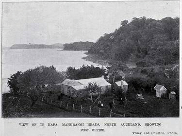
Marriage Bay was a busy shipyard producing schooners and later also cutters until 1875. The Darroch family also hosted early church services, operated a tiny post office (now at the Warkworth Museum) for 50 years to around WW1, and operated a store complete with publican’s licence.
The post office was initially at Marriage Bay and operated by the Darroch family for 50 years. It was later relocated to the roadside outside Rose Cottage (35 Ridge Road) and operated by the Lawrie family until the late 1940’s. (Warkworth Museum collection see https://scottslanding.org/the-old-post-office )
Son James Darroch took over the yard in 1862. George (Snr) died in 1877 and both James and wife Margaret in 1892. The property then passed to sister Mary (and husband coastal skipper Robert Quinn). The home and store, on a rise back from the beach had been totally destroyed by fire in 1881. It is possible that a replacement was built closer to the water and appears in the picture below. Sadly over a century later, and much to the suspicion of locals, this building was also razed by fire as a new gated development was in its planning stages.
Marriage Bay in 1900. A fire in 1881 destroyed the original homestead and store. The house (centre; possibly its replacement) was destroyed by fire in the 2000’s. The fate and date of the more substantial house just visible amongst the trees (right) is subject to further research. (Auckland Libraries Heritage Collections AWNS-19000720-5-8)
James’ sons George (Jnr) and Davey carried on the boatbuilding tradition. After the fire of 1881 Davey, who had been storekeeper at Marriage Bay, began work in Meiklejohn’s Omaha boat yard. He eventually took over their upper yard in Whangateau. His time there was certainly productive. Davey Darroch’s acclaimed boatyard produced 32 scows (including the namesake Jane Gifford now restored and plying the Mahurangi). His marriage to his erstwhile boss’s daughter Vida produced 13 children.

Acknowledgements: This account draws heavily on the impressive work of the late R H Locker, Jade River – a History of the Mahurangi ; Friends of the Mahurangi Inc, 2001. Thanks too to Joyce Anderson, Andrew Hay, Cimino Cole and Bill Townson for their contributions.
Next Location: Historical Trail Location 3 (Williams Street).
There are two options to get to the next location. The shortest but steepest route (pedestrian only) is to continue south on Young Street until you reach the walkway steps on the right opposite #21. Climb the steps and follow the short, steep path up to Ridge Road, where a right turn and a short 70 metre walk up the hill will bring you to Williams Street on the left. The seat is located about 30 metres along Williams Street, on the left, next to the steps at the top of the marked track.
The alternative route is longer but avoids the steep climb. Return via Young Street, Point Street and Charles Street to Ridge Road, then turn left at the bus shelter and head up to the top of the hill. Williams Street is on the right as you start to come down the other side of the hill. The seat is located about 30 metres along Williams Street, on the left, next to the steps at the top of the marked track.